The speedboat slowed to a crawl as we approached what the map insisted was “open water.”
Ahead, the horizon broke strangely: not a distant shore, but a raw, geometric strip of yellow sand and half-finished runways rising straight out of the sea.
Excavators squatted on the new coastline like metal insects. A lone crane traced slow arcs over a concrete skeleton that would soon be a radar dome. The water around us had turned a cloudy, chalky blue from constant dredging. Nobody spoke for a while.
This place did not exist fifteen years ago.
Now it is a “strategic outpost.”
From empty sea to airstrips and harbors
For more than a decade, China has been quietly doing something that looks like science fiction from a distance.
It has been pouring sand, gravel, and concrete into the South China Sea and other coastal zones, slowly forcing new land to rise where there was only deep water and coral.
The numbers barely fit in the mind. Dredgers the size of small apartment blocks vacuum sand from the seabed and spew it through floating pipes, day and night, like oversized firehoses.
Seen from above, the process looks like someone is drawing fresh outlines on the ocean with a highlighter pen.
One of the starkest examples is Fiery Cross Reef. Not long ago, it was a speck on maritime charts, half-submerged, known mostly to fishermen and naval officers.
Around 2014, satellite images began showing a pale halo spreading around it.
Within a handful of years, that halo hardened into a 3,000‑meter runway, deep‑water harbor, fuel depots, and military barracks.
What used to vanish under waves during storms could now host large transport planes and fighter jets, plus air defense systems.
A reef that once barely scraped the surface had been turned into a mini fortress with its own zip code and power grid.
Behind this transformation lies a simple engineering logic.
Dredgers scoop sand and crushed coral from nearby shallows, then pump it into a ring of retaining walls built on the reef or seafloor.
The fill material rises layer by layer, compacted and reinforced, until it breaks the surface and becomes stable enough for concrete.
Once the platform is dry, roads, radar domes, piers, and housing can be added with the same techniques used on land.
It’s brutal, not especially elegant, but astonishingly effective when you throw state-level money, steel, and fuel at it.
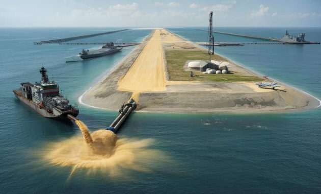
How you “build” an island, step by step
The basic method looks almost childlike if you sketch it on a napkin.
First, pick a reef, shoal, or shallow spot that offers a hard base and a good strategic view.
➡️ What psychology reveals about people who feel tension before relaxing
➡️ “I always felt behind,” until I stopped doing this one thing automatically
➡️ What the habit of piling clothes on a chair really says about you
Next, bring in cutter‑suction dredgers — hulking ships with rotating heads that chew up the seabed.
They mix the breakup with seawater and push this slurry through long pipes toward your chosen reef, where the flow dumps out in great arcs, building a mound that slowly rises from turquoise to beige.
The seductive part of this technique is how fast it seems to work.
A shape appears on the water within weeks, then months later a full‑sized strip of land is staring back at neighboring countries, radar dishes already spinning.
Many people looking at satellite images fall into the same trap: treating islands like Lego bricks you can keep snapping onto the map without consequences.
Let’s be honest: nobody really reads the fine print on erosion, fisheries collapse, or legal disputes when the first photos hit social media.
We focus on the spectacle, not the slow damage.
“You can’t just pour sand on a reef and pretend nothing lived there,” a marine biologist in Manila told me, shaking her head. “You’re erasing an ecosystem to draw a border.”
- Vast plumes of sediment smother coral and seagrass for kilometers around, killing habitats that took centuries to grow.
- Freshly made islands sink and shift, needing constant maintenance and more dredging to stay usable over time.
- Every new strip of land complicates territorial claims, pulling coast guards and warships into tighter, riskier encounters.
- Local fishers lose traditional grounds, yet rarely get a say in these decisions decided far above their heads.
The deeper stakes behind piles of sand
Once you notice these islands, you see the emotional undercurrent everywhere in the region.
Fishermen in Vietnam, the Philippines, and Malaysia tell similar stories: once‑quiet stretches of sea now filled with patrol boats, flares, and shouted warnings over loudspeakers.
What used to be a question of “where are the good fish?” turns into “whose waters are these?”
Each fresh runway poured into the sea makes that question a little sharper, a little more dangerous.
Geopolitically, the calculus is cold.
Control the islands and you project power over key shipping lanes, oil and gas fields, and future undersea cables.
From Beijing’s point of view, every artificial island is a permanent asset in a contested space, a physical statement in concrete and steel.
From Washington, Manila, or Hanoi, the same structures look like stepping stones for planes and missiles, edging closer to their shores.
*The same patch of sand can feel like security to one capital and encirclement to another.*
What makes this story unsettling is how permanent it feels once the concrete sets.
Tanks can be withdrawn, ships can sail away, treaties can be rewritten, but a runway on what used to be a reef just sits there, generation after generation.
There is no easy way to “unbuild” an island without wrecking the ocean twice over.
So every dredger run is not just a construction project; it’s a commitment, a bet that future leaders will still want that same footprint in the sea.
We’ve all been there, that moment when a quick shortcut creates a long‑term mess you didn’t really plan out.
| Key point | Detail | Value for the reader |
|---|---|---|
| China’s island‑building method | Dredging sand and coral onto reefs, compacting, then paving runways and ports | Helps you visualize how “new land” can appear so quickly on the map |
| Environmental fallout | Sediment plumes, coral destruction, changing fish stocks around the South China Sea | Clarifies the hidden ecological cost behind dramatic satellite images |
| Geopolitical impact | Stronger territorial claims, heavier military presence, tense encounters at sea | Shows why these sandy strips matter for regional stability and global trade |
FAQ:
- Question 1Why is China building artificial islands in the South China Sea?
- Question 2How long does it take to turn a reef into a usable island?
- Question 3Are other countries doing the same thing?
- Question 4What does this mean for the environment and local fishing communities?
- Question 5Could these artificial islands ever be dismantled or reversed?