At 7 a.m. on a late-winter morning, the sky above northern Europe looks oddly tired. The sunrise is pale, the air too still, and the meteorologists in a few anonymous offices are staring at their screens with the kind of focus pilots have during turbulence. High above them, about 30 kilometers over the Arctic, the polar vortex — that cold, spinning crown of air that usually holds winter in place — is starting to shudder.
The numbers look wrong. The winds that should be roaring from west to east are slowing, even turning. The core is warming up, fast.
Something in the stratosphere is about to snap, and it’s happening late in the season.
An Arctic engine about to stall
The polar vortex is usually a quiet background character, like the hum of a refrigerator you don’t notice until it stops. In March, it should be slowly unwinding as sunlight returns to the Arctic and winter fades from memory. This year, instead of fading, it’s about to be punched in the face.
A major disruption — possibly a full “sudden stratospheric warming” event — is rapidly strengthening, and the timing is odd. We’re closer to spring than deep winter. *The vortex, in theory, should be dying down, not flaring up in drama.*
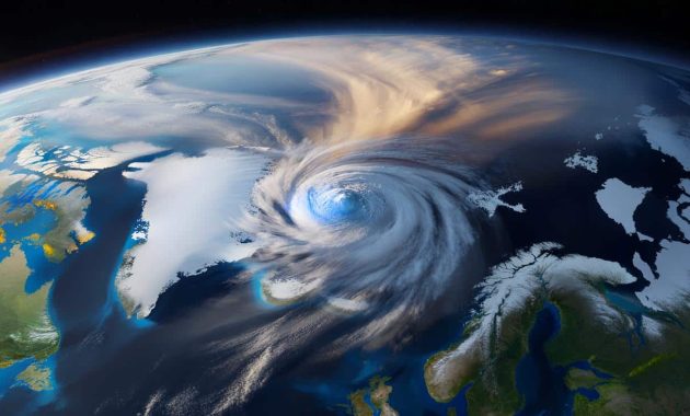
Look at the latest model animations and you see something almost cinematic. A tongue of warm air snakes up from lower latitudes and slams into the polar stratosphere. Wind speeds that were near 200 km/h start crashing. The central Arctic, usually a pool of brutal cold at high altitude, lights up on the temperature maps like a bruise turning red.
Some forecasting centers are flagging anomalies rarely seen this late in the season. One European model run shows zonal mean winds flipping direction — a classic sign of a vortex collapse — while others show a lopsided, stretched vortex spinning like a wobbling top that’s about to fall over. For meteorologists, that’s the weather equivalent of ominous music.
What does that actually mean down here, at ground level where we argue about heating bills and cherry blossoms? A disrupted polar vortex can break the usual west-to-east flow and let Arctic air leak south, while pushing warmer air north somewhere else. The jet stream can twist into deep meanders.
We don’t get a single, simple outcome. Instead, we get a higher chance of weather whiplash: a week that starts with almost springlike warmth, then flips to raw, late-season cold with frosts, snow bursts, or endless gray. The atmosphere above is rearranging its furniture. Some of that chaos will tumble down.
How to read the signs — and not lose your mind
For ordinary people, the best “method” to deal with a polar vortex disruption sounds almost boring: watch the medium-range forecasts, not just the headlines. Focus on 5–10 day outlooks for your region and pay attention to two things — temperature swings and storm tracks.
➡️ This master gardener reveals the ideal time to sow without fearing drought in 2025
➡️ Carbon dioxide ‘pulses’ clear toxins from Parkinson’s brains in recent study : ScienceAlert
➡️ No vinegar and no baking soda: pour half a glass and the drain cleans itself
➡️ A gigantic buried block beneath Hawaii may explain why volcanic hot spots stay put
➡️ “Trying a no-buy month challenge reset my spending habits and built savings”
If you live in North America or Europe, look for mentions of “blocked patterns”, “Greenland blocking”, or “Arctic outbreaks”. Those phrases are code for the jet stream slowing and buckling, which is what a disturbed vortex loves to do. Check the daily highs and lows, not just the icons. A 10–15°C swing between days is the signature of the atmosphere being shaken from above.
We’ve all been there, that moment when you walk outside in a light jacket because yesterday felt like April… and you immediately regret everything. A disrupted polar vortex is basically that feeling, but scaled up across continents.
One common trap is to react to a single eye-catching map on social media — “Europe to freeze!” or “US faces March snowstorm!” — and treat it as destiny. Models wobble when the stratosphere is disturbed. The atmosphere is literally being kicked out of balance. Let yourself adjust in stages instead: first accept increased uncertainty, then track how forecasts converge (or don’t) as the event approaches.
“People hear ‘polar vortex’ and imagine some new monster we didn’t have before,” a senior forecaster in Berlin told me last week. “The truth is, the vortex has always been there. What’s unusual this time is the timing and the strength of the disruption. It’s like getting a January-style hit in mid to late March.”
- Watch for pattern shifts, not single days
If forecasts mention blocking or high-latitude ridges, it often signals that the stratospheric shake-up is bending the jet stream, which can lock in cold or mild spells longer than usual. - Use simple layers, not seasonal assumptions
That “spring is here” feeling is fragile during a vortex disruption. Keep gloves, a hat, and a warmer coat within reach, even if daffodils are already out. - Think impacts, not jargon
For daily life, what matters is: Will roads ice up? Could late frosts hit gardens or farms? Could heavy, wet snow weigh on roofs or power lines? Translate “stratospheric warming” into real-world decisions.
What this says about our changing winters
There’s a delicate tension here. On one hand, the stratosphere has always thrown curveballs. Sudden stratospheric warming events were documented long before climate change became a household term. On the other hand, a growing body of research is probing whether a warmer, patchier Arctic is interfering with the polar vortex more often, or in stranger ways, especially late in the season.
Some studies suggest that reduced sea ice and warmer northern seas can feed more wave energy upwards into the stratosphere, jostling the vortex and making disruptions stronger or more frequent. Other scientists are more cautious, arguing the long-term trend is messy and not yet nailed down. Let’s be honest: nobody really does this every single day, digging through academic PDFs before checking the weather app.
| Key point | Detail | Value for the reader |
|---|---|---|
| Unusual timing | Strong polar vortex disruption developing in March rather than mid-winter | Signals that late-season weather may be more volatile than a “normal” early spring |
| Jet stream twists | Higher chance of blocking patterns, cold outbreaks in some regions and warmth in others | Helps you prepare for sudden flips in temperature, travel disruption, or late frosts |
| Climate context | Scientists studying links between Arctic change and vortex behavior | Offers a bigger picture on why our winters feel less predictable year after year |
FAQ:
- Question 1What exactly is the polar vortex, in simple terms?
It’s a huge, spinning pool of very cold air high above the Arctic, in the stratosphere, that helps keep winter cold “locked” near the pole when it’s strong and stable.- Question 2Does a polar vortex disruption always mean extreme cold where I live?
No. It increases the chance of cold outbreaks in some regions, but others can end up milder than normal. The key effect is a more wavy, less predictable jet stream.- Question 3How long after the disruption do surface impacts usually show up?
Often 1–3 weeks. The signal needs time to “propagate” downward from the stratosphere before it reshapes the weather patterns we feel on the ground.- Question 4Is this unusual March event linked to climate change?
Scientists are actively studying that question. There are hints of a connection via Arctic warming and sea ice loss, but the relationship isn’t fully settled or simple.- Question 5What should I actually do about this as an ordinary person?
Follow regional forecasts closely over the next few weeks, stay flexible with travel or outdoor plans, and keep winter gear handy even if spring seems to have started.